
2026 , Vol. 16 >Issue 5: 43 - 50
DOI: https://doi.org/10.11923/j.issn.2095-4050.cjas2025-0048
GIS-based Suitability Evaluation and Analysis of Agricultural Land in Pingyin County
Received date: 2025-02-08
Revised date: 2025-07-10
Online published: 2026-05-15
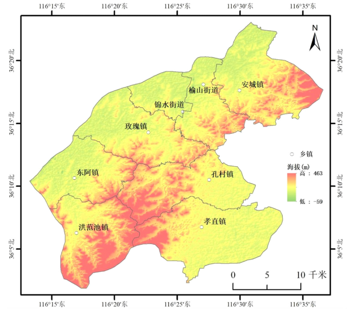
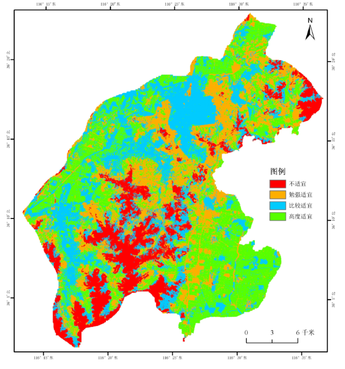
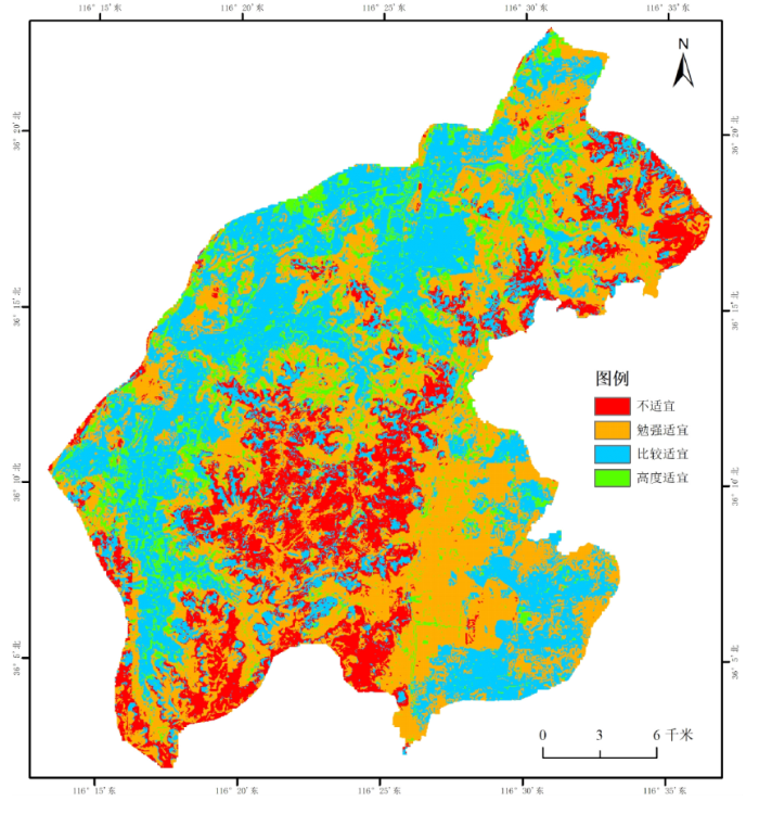
To protect agricultural land and improve the efficiency of agricultural land use in Pingyin County, a suitability evaluation of agricultural land in Pingyin County was conducted. Based on the data of land use status of the third land survey in Pingyin County, this study selected nine evaluation factors, including topography, soil, water resources, and human and social factors, to construct an evaluation index system. Using the principal component analysis method to determine the factor weight, combined with GIS spatial analysis and natural breakpoint classification method, the suitability evaluation of cultivated land, garden land and forest land in Pingyin County was carried out. The results show that: (1) the proportion of highly suitable farmland in Pingyin County is 33%, concentrated along the northwest bank of the Yellow River and the southeast bank of the Hui River. (2) The proportion of areas suitable for gardens and forests is around 11%, distributed relatively loosely, while the southern central mountainous region is generally less suitable. (3) Due to the influence of mountainous terrain, the suitability of agricultural land varies among townships, with uneven spatial distribution. In particular, more than half of the arable land in Xiaozhi Township is highly suitable. This GIS comprehensive suitability assessment aims to identify potential agricultural land and provide support for scientific planning and optimization of agricultural land spatial layout.
FENG Pengfei , SHEN Chenglong , JIANG Huizhong . GIS-based Suitability Evaluation and Analysis of Agricultural Land in Pingyin County[J]. Journal of Agriculture, 2026 , 16(5) : 43 -50 . DOI: 10.11923/j.issn.2095-4050.cjas2025-0048
表1 数据类型及数据来源 |
| 数据 | 来源 |
|---|---|
| 土壤类型 | 国家地球系统科学数据中心(https://www.geodata.cn) |
| 土壤pH | 国家青藏高原科学数据中心 (https://data.tpdc.ac.cn/home) |
| 土壤有机质 | |
| 行政区划 | 地理空间数据云(http://www.gscloud.cn/) |
| 地形数据 | |
| 交通数据 | OSM数据集 |
| 水系数据 | |
| 土地利用现状 | 第三次全国国土调查 |
表2 平阴县农用地适宜性评价指标及分级标准 |
| 评价因子 | 6分 | 5分 | 4分 | 3分 | 2分 | 1分 |
|---|---|---|---|---|---|---|
| DEM/m | <50 | 50~90 | 90~135 | 135~190 | 190~260 | >260 |
| 坡度/° | <2 | 2~5 | 5~10 | 10~15 | 15~20 | >20 |
| 距水系距离/km | <1.5 | 1.5~3 | 3~5 | >5 | ||
| 距道路距离/km | <1 | 1~2 | 2~3 | 3~4 | 4~5 | >5 |
| 居民点/km | <0.3 | 0.3~0.6 | 0.6~1 | 1~2 | 1.5~2 | >2 |
| 土壤类型 | 褐土、潮褐土、褐土性土 | 潮土 | 石灰性褐土 | 钙质粗骨土 | 石灰性砂姜黑土 | 冲积土、其他 |
| 土壤pH | <7.5 | - | 7.5~8 | - | - | >8 |
| 土壤有机质/(g/kg) | >2.6 | 2.1~2.6 | 1.6~2.1 | 1.2~1.6 | 0.8~1.2 | <0.8 |
表3 评价因子权重值 |
| 评价因子 | 耕地 | 园地 | 林地 |
|---|---|---|---|
| DEM | 0.112 | 0.111 | 0.124 |
| 坡度 | 0.123 | 0.124 | 0.176 |
| 距水系距离 | 0.142 | 0.098 | 0.091 |
| 距道路距离 | 0.083 | 0.079 | 0.081 |
| 距居民点距离 | 0.096 | 0.092 | 0.075 |
| 现状用地 | 0.225 | 0.223 | 0.223 |
| 土壤类型 | 0.099 | 0.153 | 0.12 |
| 土壤pH | 0.06 | 0.06 | 0.06 |
| 土壤有机质 | 0.06 | 0.06 | 0.05 |
表4 各乡镇耕地综合评价分析表 |
| 乡镇 | 高度适宜/km2 | 比例/% | 比较适宜/km2 | 比例 | 勉强适宜/km2 | 比例 | 不适宜/km2 | 比例 | 总计/km2 |
|---|---|---|---|---|---|---|---|---|---|
| 孝直镇 | 70.99 | 56.81 | 20.99 | 16.80 | 20.93 | 16.75 | 12.06 | 9.65 | 124.97 |
| 东阿镇 | 30.97 | 38.58 | 25.42 | 31.66 | 15.7 | 19.56 | 8.19 | 10.20 | 80.28 |
| 安城镇 | 37.28 | 33.66 | 22.17 | 20.02 | 37.87 | 34.19 | 13.43 | 12.13 | 110.75 |
| 玫瑰镇 | 30.02 | 31.11 | 33.75 | 34.97 | 26.51 | 27.47 | 6.22 | 6.45 | 96.5 |
| 锦水街道 | 9.21 | 25.60 | 19.75 | 54.91 | 6.8 | 18.90 | 0.21 | 0.58 | 35.97 |
| 孔村镇 | 24.11 | 24.61 | 22.76 | 23.23 | 27.17 | 27.74 | 23.92 | 24.42 | 97.96 |
| 洪范池镇 | 18 | 19.48 | 24.79 | 26.83 | 16.43 | 17.78 | 33.17 | 35.90 | 92.39 |
| 榆山街道 | 10.65 | 17.41 | 28.1 | 45.95 | 19.35 | 31.64 | 3.06 | 5.00 | 61.16 |
| 总计 | 231.23 | 33.03 | 197.73 | 28.25 | 170.76 | 24.39 | 100.26 | 14.32 | 699.98 |
表5 各乡镇园地综合评价分析表 |
| 乡镇 | 高度适宜/km2 | 比例/% | 比较适宜/km2 | 比例/% | 勉强适宜/km2 | 比例/% | 不适宜/km2 | 比例/% | 总计/km2 |
|---|---|---|---|---|---|---|---|---|---|
| 玫瑰镇 | 16.35 | 16.94 | 46.04 | 47.70 | 27.95 | 28.96 | 6.17 | 6.39 | 96.51 |
| 榆山街道 | 9.58 | 15.66 | 29.16 | 47.67 | 18.94 | 30.96 | 3.49 | 5.71 | 61.17 |
| 锦水街道 | 4.58 | 12.73 | 22.92 | 63.70 | 8.25 | 22.93 | 0.23 | 0.64 | 35.98 |
| 东阿镇 | 8.99 | 11.20 | 37.05 | 46.15 | 24.98 | 31.12 | 9.26 | 11.53 | 80.28 |
| 孔村镇 | 9.83 | 10.04 | 25.63 | 26.17 | 34.34 | 35.06 | 28.15 | 28.74 | 97.95 |
| 安城镇 | 10.5 | 9.48 | 22.69 | 20.49 | 61.15 | 55.22 | 16.39 | 14.80 | 110.73 |
| 孝直镇 | 11.42 | 9.14 | 47.02 | 37.63 | 50.41 | 40.34 | 16.1 | 12.89 | 124.95 |
| 洪范池镇 | 7.51 | 8.13 | 25.1 | 27.16 | 24.47 | 26.48 | 35.32 | 38.23 | 92.4 |
| 总计 | 78.76 | 11.25 | 255.61 | 36.52 | 250.49 | 35.79 | 115.11 | 16.44 | 699.97 |
表6 各乡镇林地综合评价分析表 |
| 乡镇 | 高度适宜/km2 | 比例/% | 比较适宜/km2 | 比例/% | 勉强适宜/km2 | 比例/% | 不适宜/km2 | 比例/% | 总计/km2 |
|---|---|---|---|---|---|---|---|---|---|
| 玫瑰镇 | 14.83 | 15.37 | 43.63 | 45.21 | 30.36 | 31.46 | 7.69 | 7.97 | 96.51 |
| 安城镇 | 13.92 | 12.57 | 28.03 | 25.31 | 50.23 | 45.36 | 18.56 | 16.76 | 110.74 |
| 东阿镇 | 12.4 | 15.45 | 35.18 | 43.82 | 23.52 | 29.30 | 9.18 | 11.43 | 80.28 |
| 榆山街道 | 8.92 | 14.58 | 31.04 | 50.74 | 16.37 | 26.76 | 4.84 | 7.91 | 61.17 |
| 锦水街道 | 8.14 | 22.62 | 20.36 | 56.59 | 6.79 | 18.87 | 0.69 | 1.92 | 35.98 |
| 洪范池镇 | 7.78 | 8.42 | 27.42 | 29.68 | 33.84 | 36.63 | 23.35 | 25.27 | 92.39 |
| 孔村镇 | 5.84 | 5.96 | 18.16 | 18.54 | 43.73 | 44.65 | 30.22 | 30.85 | 97.95 |
| 孝直镇 | 3.92 | 3.14 | 40.15 | 32.14 | 64.92 | 51.96 | 15.95 | 12.77 | 124.94 |
| 总计 | 75.75 | 10.82 | 243.97 | 34.85 | 269.76 | 38.54 | 110.48 | 15.78 | 699.96 |
| [1] |
韩杨. 中国耕地保护利用政策演进、愿景目标与实现路径[J]. 管理世界, 2022, 38(11):121-131.
|
| [2] |
郑宇, 胡业翠, 刘彦随, 等. 山东省土地适宜性空间分析及其优化配置研究[J]. 农业工程学报, 2005(2):60-65.
|
| [3] |
郭鹏, 管宏梓, 李鹏辉, 等. 基于ArcGIS技术的耕地后备资源调查评价研究——以济南市平阴县为例[J]. 地下水, 2024, 46(5):192-194.
|
| [4] |
江红蕾, 徐霞, 成亚薇, 等. 基于生态可持续的土地利用空间格局分配[J]. 中国农学通报, 2017, 33(33):67-73.
|
| [5] |
李德仁. 论RSGPS与GIS集成的定义、理论与关键技术[J]. 遥感学报, 1997(1):64-68.
|
| [6] |
袁媛, 瑚波, 雷蕾, 等. GIS支持下的商南县小麦生态适宜性评价及种植区划[J]. 中国农学通报, 2017, 33(21):7-14.
|
| [7] |
赵晓峰, 刘晓煌, 刘玖芬, 等. 基于多环境要素的新疆耕地适宜性评价[J]. 现代地质, 2024, 38(3):718-733.
|
| [8] |
|
| [9] |
|
| [10] |
陈颖, 吴柏清, 邹卓阳, 等. 基于GIS的土地适宜性评价——以四川省马尔康县为例[J]. 水土保持研究, 2010, 17(4):100-103.
|
| [11] |
陈露露, 杜泳, 颉洪涛. 基于GIS的浙江省诸暨市农业用地适宜性分析与评价[J]. 中国农学通报, 2023, 39(21):158-164.
|
| [12] |
李潇, 吴克宁, 刘亚男, 等. 基于土地类型的西峡县农用地适宜性评价[J]. 中国农业资源与区划, 2024, 45(1):45-56.
|
| [13] |
潘贤章, 潘恺. 全国土壤标本数据库(1953—2008)[Z].国家地球系统科学数据共享平台-土壤科学数据中心,2015.
|
| [14] |
方华军. 青藏高原地区土壤有机质数据(1979—1985)[Z]. 国家青藏高原科学数据中心.国家青藏高原科学数据中心,2019.
|
| [15] |
李蓉. 基于GIS的七台河市耕地适宜性评价[J]. 哈尔滨师范大学自然科学学报, 2019, 35(4):94-101.
|
| [16] |
伍世代. GIS支持的福清市多目标土地适宜性评价[J]. 福建师范大学学报(自然科学版), 2000(3):87-90.
|
| [17] |
聂艳, 喻婧, 崔灿. 基于GIS和生态位适宜度模型的园地适宜性评价——以湖北宜昌市夷陵区为例[J]. 长江流域资源与环境, 2012, 21(8):1000-1005.
|
| [18] |
李鹏飞. 基于GIS的定西市农用地适宜性评价分析[J]. 河南科技, 2023, 42(5):116-119.
|
| [19] |
李娅, 谭秋, 王丽双, 等. 县域农业土地利用适宜性评价与优化研究——以山西省原平市为例[J]. 中国农业资源与区划, 2022, 43(1):91-99.
|
| [20] |
朱寿红, 殷少美, 唐伟, 等. 基于资源承载力的农用地适宜性评价——以广陵区为例[J]. 江西农业学报, 2021, 33(1):117-122.
|
| [21] |
全国土壤质量标准化技术委员会(SAC/TC 404). GB/T 33469-2016,耕地质量等级[S]. 北京: 中国标准出版社, 2016.
|
| [22] |
李乃强, 徐贵阳. 基于自然间断点分级法的土地利用数据网格化分析[J]. 测绘通报, 2020(4):106-110.
|
| [23] |
高尚. 三种计算层次分析法中权值的方法[J]. 科学技术与工程, 2007(20):5204-5207.
|
| [24] |
董君. 层次分析法权重计算方法分析及其应用研究[J]. 科技资讯, 2015, 13(29):218-220.
|
| [25] |
陈德桃, 程文仕. 基于效益最大化的景泰县农地适度经营规模测度及驱动力分析[J]. 国土与自然资源研究, 2025(2):17-21.
|
| [26] |
白璐. 基于适宜性原理的河南省耕地利用强度分析[D]. 开封: 河南大学, 2010.
|
/
| 〈 |
|
〉 |
