
Multi-dimensional deformation inversion of landslides using combined sentinel-1A ascending and descending orbit data
Received date: 2023-08-03
Online published: 2024-09-29
Copyright
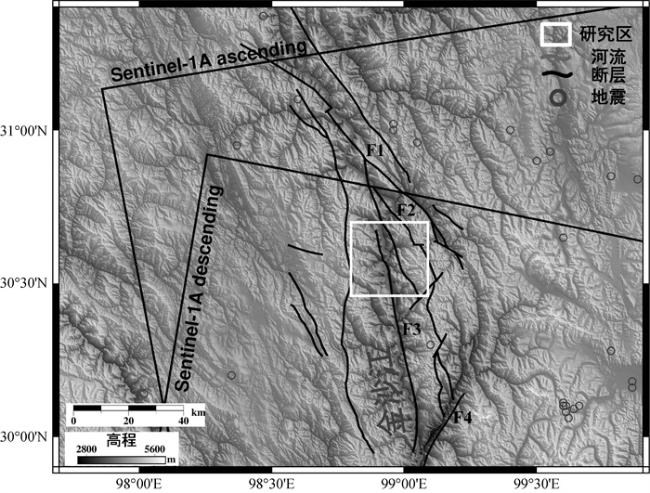
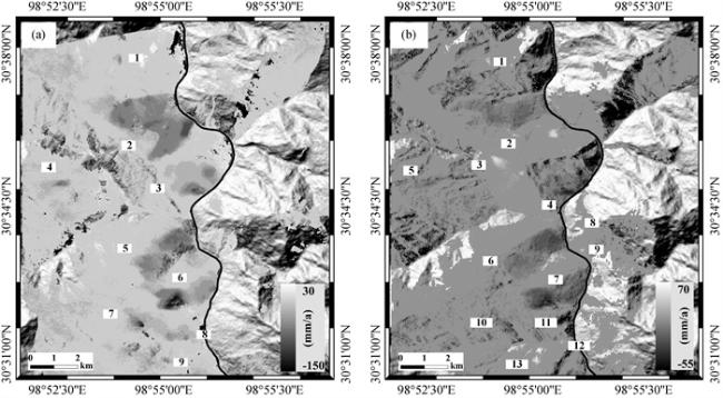
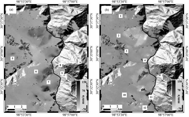
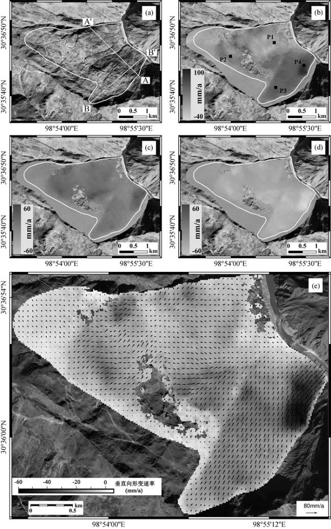
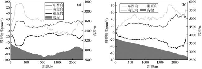
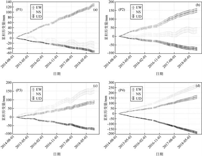
The Jinsha River,located in the upper reaches of the Yangtze River,is prone to frequent geological hazards on both sides due to its unique terrain and geological conditions. Firstly,the article employed the SBAS-InSAR technique to capture the surface deformation characteristics of landslides in the Gongjue County of the Jinsha River Basin in the Tibet Autonomous Region,spanning the period from October 2014 to October 2018, spanning from Shadong Township to Xiongsong Township. Subsequently,by integrating ascending and descending orbit DInSAR datasets,the two-dimensional deformation information was obtained in this region. Building upon this foundation,the Shadong landslide was selected as the research subject,the surface parallel flow constraint model was introduced to conduct three-dimensional deformation monitoring studies on the landslide.The results show that: (1) The study area is characterized by fragmented terrain and the development of geological hazards. Utilizing ascending and descending orbit Sentinel-1A data,nine and thirteen deformation regions were detected,respectively. Among them,the maximum deformation rate in certain areas reached 150 mm/year.(2) The two-dimensional deformation results reveal that the maximum deformation rates in the east-west and vertical directions are 147 mm/year and-70 mm/year,respectively. The spatial distribution characteristics of landslide deformation vary significantly at different locations. (3) The presentation of the three-dimensional deformation results shows the movement direction of the Shadong landslide in various locations,with the slope mainly moving in the northeast direction and accompanied by a sinking state. (4) Based on the rainfall factors in the region,the correlation between typical landslide deformation and rainfall was analyzed. The results show that Intense rainfall is critical driving factor for accelerating landslide deformation.
Quan ZHOU , YaNan JIANG , Peng LÜ , Dong WANG , Rui ZENG . Multi-dimensional deformation inversion of landslides using combined sentinel-1A ascending and descending orbit data[J]. Progress in Geophysics, 2024 , 39(4) : 1427 -1439 . DOI: 10.6038/pg2024HH0288
表1 Sentinel-1A数据参数Table 1 Sentinel-1A data parameters |
| 参数 | 相应值 | 相应值 |
| 轨道方向 | 升轨 | 降轨 |
| 雷达入射角/(°) | 36.7765 | 42.3285 |
| 卫星飞行方位角/(°) | -12.753181 | 192.744183 |
| 数据量/(景) | 82 | 76 |
| 时间段 | 2014-10-12—2018-10-27 | 2014-10-07—2018-09-28 |
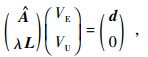
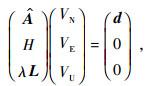
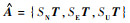 ,T矩阵为SAR矩阵时间间隔(公式),S矩阵分别为LOS向的南北向、东西向和垂直向的三个分量,S ={SN, SE, SU}={sinαsinθ, -cosαsinθ, cosθ},
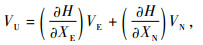
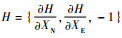 为地表平行流约束.VN、VE和VU分别为待求的南北向、东西向和垂直向形变速率,通过奇异值分解(SVD)可以求得.
图7 三维形变速率(a)光学影像;(b)南北向形变速率;(c)东西向形变速率;(d)垂直向形变速率;(e)沙东滑坡水平运动矢量. Fig 7 Three-dimensional displacement rate (a) Optical image; (b) North-south displacement rate; (c) East-west displacement rate; (d) Vertical displacement rate; (e) The horizontal movement vector of the Shadong landslide. |
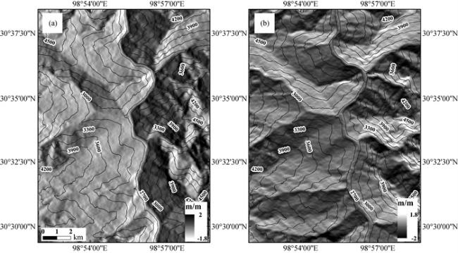
图8 沿剖线AA′(a)和BB′(b)的三个分量的形变速率和高程Fig 8 Deformation rate and elevation of the three components along the section lines AA′(a) and BB′ (b) |
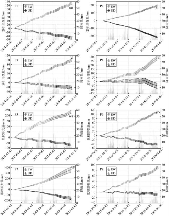
表2 形变点分阶段形变速率统计(单位:mm/month)Table 2 Statistics of deformation rate at different stages of deformation points (unit: mm/month) |
| 时间段 | 2014-11—2015-03 | 2015-05—2015-09 | 2015-11—2016-03 | 2016-05—2016-09 | 2016-11—2017-03 | 2017-05—2017-09 | 2017-11—2018-03 | 2018-05—2018-09 | |
| P1 | EW | 3 | 3.2 | 2.7 | 2.3 | 2.5 | 2.6 | 2.5 | 2.9 |
| UD | -1.5 | -1.3 | -1 | -0.9 | -0.5 | -1.6 | -0.9 | -1.5 | |
| P3 | EW | 1.7 | 2 | 2 | 3 | 1.8 | 2.6 | 1.4 | 2.6 |
| UD | -0.3 | 0.1 | -1 | -0.3 | -0.9 | -0.3 | -0.3 | -0.8 | |
| P4 | EW | 2.6 | 4 | 4.9 | 3.3 | 2.7 | 8.9 | 10.2 | 10.4 |
| UD | 0.1 | -0.5 | -0.3 | 1.2 | -0.5 | 0.5 | -5.9 | -5.1 | |
| P5 | EW | 7.2 | 6.4 | 6.3 | 4.4 | 4.4 | 3.9 | 2.2 | 5.8 |
| UD | -2.4 | 0.6 | -2.8 | 0.1 | -1.7 | -2.3 | -0.5 | -2.5 | |
| P6 | EW | 1.7 | 1.6 | 1.6 | 1.7 | 2.1 | 3.6 | 2.6 | 2.7 |
| UD | -1.2 | -0.6 | -0.8 | -0.2 | -1.4 | -0.4 | -1.7 | -0.3 | |
| P8 | EW | 1.5 | 2.2 | 1.7 | 2.1 | 2.3 | 2.8 | 1.4 | 2.6 |
| UD | 0.1 | 0.3 | -0.5 | -0.3 | -0.4 | -0.4 | 0.3 | -0.7 | |
感谢审稿专家提出的修改意见和编辑部的大力支持!
|
|
|
|
|
|
|
|
|
|
|
|
|
|
|
|
|
|
|
|
|
|
|
|
|
|
|
|
|
|
|
|
|
|
|
|
|
|
|
|
|
|
|
|
|
|
|
|
|
|
|
|
|
|
|
|
|
|
|
|
|
|
|
|
|
|
|
|
/
| 〈 |
|
〉 |

