
Forensic military geophysics: battlefield reconnaissance and trace identification
Received date: 2024-05-22
Online published: 2025-03-13
Copyright
Forensic military geophysics is a new branch of military geophysics in the field of military intelligence reconnaissance and identification with high-resolution measurements of the shallow underground layers of geophysical methods on typical military scenes including of the medium and small-scale battlefield spaces of tactics and combat military activities, which is used to directly verify the geological structure information of the reachable area, so as to infer the geophysical characteristics of the detection targets in the unreachable area by a close analogy of similarity in geological environment, and to solve the problem of effective reconnaissance and identification of geological intelligence evidence in the unfamiliar battlefield environment. A series of geophysical methods mainly include electrical methods, electromagnetic methods, seismic exploration and magnetic methods, which are applied to military scenes of the known battlefield environmental survey and the unknown battlefield intelligence reconnaissance. The key of the application to forensic military geophysical methods is similarity, contrast, rapidity, and non-destructive testing, which extremely could be in accordance with reconnaissance and identification to the physical characteristics of hidden objects as evidence constraints of battlefield environmental intelligence. The three types of typical examples consisting of projectile contact explosion damage effect in battlefield reconnaissance, military vehicle maneuverability in trace identification, and hidden target search underwater indicated that the resistivity method, R-wave survey and Ground Penetrating Radar (GPR) have a good identification effect on the remains evidence from military activities in shallow subsurface. This paper proposes that the multi-method application of forensic military geophysics is suitable to investigate and take the evidence for subsurface geological information of battlefield dynamic change conditions. The combination of geological and geophysical methods can effectively enhance the evidence identification effect. A multifaceted approach to the study of forensic geophysics and military geology will promote the theoretical innovation and practical application of military geophysics.
Dong ZHANG , LiangSheng GE , XinBiao LÜ , Bin WANG , JiaPan YAN , YuKun YANG , Kun REN . Forensic military geophysics: battlefield reconnaissance and trace identification[J]. Progress in Geophysics, 2025 , 40(1) : 372 -386 . DOI: 10.6038/pg2025II0138
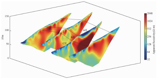
图1 落弹区岩土介质界面的温纳模式高密度电法视电阻率联合断面图A区:基岩上覆土区;B区:基岩风化带区;C区:土体区. Fig 1 Joint section of apparent resistivity of high-density resistivity method with WS arrays profile in geomaterial of drop zone Area A: Overburden soil on bedrock; Area B: Bedrock weathering zone; Area C: Soil mass. |
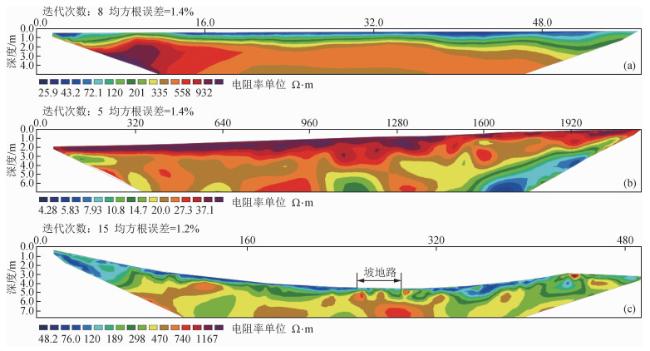
图4 高密度电阻率法探测机动区土层结构二维剖面(a) 水网地软土区1.0 m极距温纳模式探测;(b) 山间谷地硬土区5.0 m极距温纳模式探测;(c) 山坡起伏地夹石土区10.0 m极距温纳模式探测. Fig 4 High density resistivity method for 2D layered soil structure of maneuvering area (a) 1.0 m spacing WS arrays profile for the soft-soil in rivers network; (b) 5.0 m spacing WS arrays profile for the hard-soil in mountain valley; (c) 10.0 m spacing WS arrays profile for the gravels in undulating mountains. |
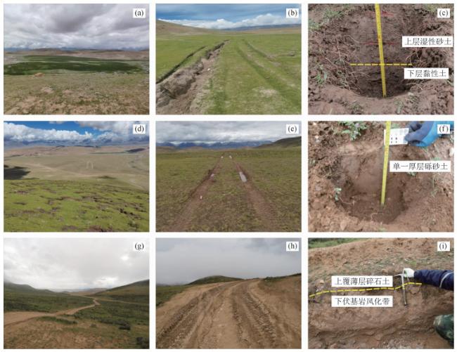
图5 与图 4对应的机动区不同土体介质的痕迹外观(a) 水网地软土区地貌;(b) 水网地软土的装备机动痕迹;(c) 水网地软土的浅表土层结构;(d) 山间谷地硬土区地貌;(e) 山间谷地硬土的装备机动痕迹;(f) 山间谷地硬土的浅表土层结构;(g)山坡起伏地夹石土区地貌;(h) 山坡起伏地夹石土的装备机动痕迹;(i) 山地起伏地夹石土的浅表土层结构. Fig 5 Trace appearance in geomaterial of maneuvering area corresponding to Fig. 4 (a) Landform of the soft-soil in rivers network; (b) Trace appearance of the soft-soil in rivers network; (c) Shallow topsoil structure of the soft-soil in rivers network; (d) Landform of the hard-soil in mountain valley; (e) Trace appearance of the hard-soil in mountain valley; (f) Shallow topsoil structure of the hard-soil in mountain valley; (g) Landform of the gravels in undulating mountains; (h) Trace appearance of the gravels in undulating mountains; (i) Shallow topsoil structure of the gravels in undulating mountains. |
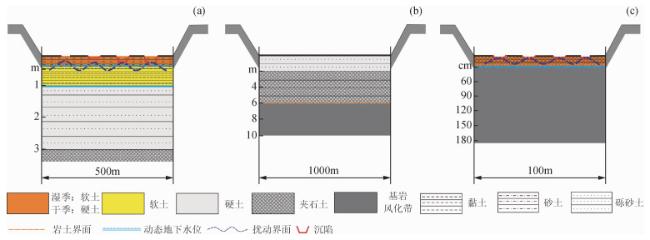
图6 机动区典型地形浅埋土层结构反演解释示意图(a) 水网地上硬(动态)下软结构模式;(b) 山间谷地单一厚层结构模式;(c) 坡地起伏路上软(动态)下硬结构模式. Fig 6 Geological sketch of the shallow layered soil structure of maneuvering area (a) Model of upper hard (dynamic) and lower soft alternation in rivers network; (b) Model of single thick layer in mountain valley; (c) Model of upper soft (dynamic) and lower hard alternation in undulating mountains. |
研究成果得到自然资源部军事地质研究与应用科技创新团队支撑,论文得到军委某科技委专家指导,在此表示感谢,同时感谢审稿专家提出的修改意见.
|
|
|
|
|
|
|
|
|
|
|
|
|
Fleming S, McDonald E V, Bacon S N. 2016. Military test site characterization and training future officers—an integrated terrain analysis approach. //McDonald E V, Bullard T eds. Military Geosciences and Desert Warfare: Past Lessons and Modern Challenges. New York: Springer, 273-295, doi: 10.1007/978-1-4939-3429-4_18.
|
|
Galgano F A, Rose E P F. 2021. Military geosciences. //Alderton D H M, Harmon R S eds. Encyclopedia of Geology. 2nd ed. Oxford: Academic Press, 648-659.
|
|
|
|
Gross M R, Ghosh K, Manda A K, et al. 2004. A GIS-based spatial analysis of caves and solution cavities: application to predicting cave occurrence in limestone terrain. //Caldwell D R, Ehlen J, Harmon R S eds. Studies in Military Geography and Geology. Dordrecht: Springer, 287-306.
|
|
|
|
|
|
Huang S Q, Liu D Z. 2005. The studies and applications of intelligence reconnaissance and identification in geophysics for national security. //The Essays collection of Geophysics in Shanxi Province: National Security and Military Geophysics (5th) (in Chinese). Xi'an: Chinese Geophysical Society, 81-85.
|
|
|
|
|
|
|
|
|
|
|
|
|
|
|
|
|
|
|
|
Liu D Z. 2007b. The review and prospect: military geophysics. //The Essays Collection of the Anniversary Meeting (20th) of Geophysical Special Committee in Shanxi Province (in Chinese). Xi'an: Chinese Geophysical Society, Shaanxi Geophysical Society, 41-46.
|
|
Liu D Z. 2008. The past, present and future on military geophysics. //The Essays Collection of Symposium of Geophysics for National Security (4th) (in Chinese). Qingdao: Chinese Geophysical Society, Shaanxi Geophysical Society, 1-9.
|
|
|
|
|
|
Liu Z G, Qian C S. 2007. The situation analysis on technology of evaluation of striking effects in U.S. forces. //The Essays Collection of Symposium of Geophysics for National Security (3rd) (in Chinese). Xi'an: Chinese Geophysical Society, 187-190.
|
|
|
|
|
|
|
|
|
|
|
|
|
|
|
|
|
|
|
|
Roskin J. 2016. Analysis of recurring sinking events of armored tracked vehicles in the Israeli agricultural periphery of the Gaza Strip. //McDonald E V, Bullard T eds. Military Geosciences and Desert Warfare: Past Lessons and Modern Challenges. New York: Springer, 339-352, doi: 10.1007/978-1-4939-3429-4_21.
|
|
|
|
|
|
Sabol Jr D E, Minor T B, McDonald E V, et al. 2016. Parent material mapping of geologic surfaces using ASTER in support of integrated terrain forecasting for military operations. //McDonald E V, Bullard T eds. Military Geosciences and Desert Warfare: Past Lessons and Modern Challenges. New York: Springer, 311-337, doi: 10.1007/978-1-4939-3429-4_20.
|
|
|
|
|
|
|
|
|
|
|
|
|
|
Zhang D, Lu Y M, Yuan S S, et al. 2021a. The concept and application of geological operations methods. //The Abstract Collection of the Anniversary Meeting (3rd) of Battlefield Environment Support (in Chinese). 63-64.
|
|
Zhang D, Ge L S, Lü X B, et al. 2021b. The sustainability of military geology: the typical applications to assist ground military operations. //The Excellent Essays Collection of the Anniversary Meeting(3rd) of Battlefield Environment Support (in Chinese). 202-211.
|
|
|
|
Zhang J C, Fan Q X, Han R F. 2008. On applied thinking to military activities of geophysical methods. //The Essays Collection of Symposium of Geophysics for National Security (4th) (in Chinese). Qingdao: Chinese Geophysical Society, Shaanxi Geophysical Society, 36-41.
|
|
|
|
|
|
|
|
|
|
|
|
|
|
|
|
|
|
|
|
黄世奇, 刘代志. 2005. 国家安全地球物理情报侦测技术研究及应用. //陕西地球物理文集(五)国家安全与军事地球物理研究. 西安: 中国地球物理学会, 81-85.
|
|
|
|
|
|
|
|
|
|
|
|
刘代志. 2007b. 军事地球物理学: 回顾与前瞻. //中国西部地球物理研究与实践陕西省地球物理学会成立20周年专集. 西安: 中国地球物理学会, 陕西省地球物理学会, 41-46.
|
|
刘代志. 2008. 军事地球物理学的过去、现在与未来. //第四届国家安全地球物理学术研讨会论文集. 青岛: 中国地球物理学会, 陕西省地球物理学会, 1-9.
|
|
|
|
|
|
刘志刚, 钱昌松. 2007. 美军打击效果评估技术的现状分析. //第三届国家安全地球物理学术研讨会论文集. 西安: 中国地球物理学会, 187-190.
|
|
|
|
|
|
|
|
|
|
|
|
|
|
|
|
张栋, 路彦明, 袁士松, 等. 2021a. 地质环境保障的概念思维与运用设想. //第三届战场环境保障学术年会论文摘要集. 63-64.
|
|
张栋, 葛良胜, 吕新彪, 等. 2021b. 军事地质的可持续性: 支持地面军事行动的典型应用. //第三届战场环境保障学术年会优秀论文集. 202-209.
|
|
|
|
张金城, 范启雄, 韩若飞. 2008. 地球物理方法在军事领域的应用思考. //第四届国家安全地球物理学术研讨会论文集. 青岛: 中国地球物理学会, 陕西省地球物理学会, 36-41.
|
|
|
|
|
/
| 〈 |
|
〉 |