
Influence of water level fluctuation on landslide deformation in Baihetan reservoir area
Received date: 2024-03-27
Online published: 2025-03-13
Copyright
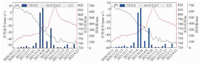
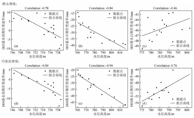
Landslides in the reservoir area are a key issue of national hydropower engineering safety and geological disaster prevention and control. During the water storage cycle, the water level in the reservoir area changes significantly, and water level fluctuations have a strong triggering effect on landslides in the reservoir area. This article takes the Baihetan hydropower station reservoir area as the research area, uses Small-Baseline Subset InSAR technology, combined with Sentinel-1 A data from the lifting rail, to monitor deformation in the early, middle, and late stages of water storage in the research area, and studies the impact of water level changes in the reservoir area on landslide deformation. The results showed that: (1) deformation monitoring was carried out in the study area using InSAR technology, and 11 unstable slopes were detected, with the maximum deformation reaching 0.14 m. Among them, 4 were known landslides, and deformation monitoring was carried out on typical landslides to study the impact of water level changes in the reservoir area on deformation; (2) Taking the cross mountain landslide and Qiaojia County landslide as examples, this study investigates the correlation between water level fluctuations and landslide deformation. Through Pearson correlation coefficient research, it is found that there is a strong correlation between significant changes in water level and landslide deformation rate. The correlation between the two is highest in the middle stage of water storage, and the impact of rising water level in the reservoir area on landslide deformation is greater than that of falling water level; (3) Taking a typical landslide as an example, a lag study was conducted on the water level and landslide deformation in the reservoir area through wavelet analysis. It was found that there is a lag period of about three to four months between the landslide deformation and water level fluctuations in the reservoir area.
ShenHe WANG , ShiJie WANG . Influence of water level fluctuation on landslide deformation in Baihetan reservoir area[J]. Progress in Geophysics, 2025 , 40(1) : 94 -105 . DOI: 10.6038/pg2025HH0580
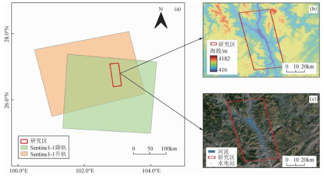
图1 研究区概况图(a)Sentinel-1A数据空间覆盖图;(b)研究区DEM;(c)研究区光学影像. Fig 1 Overview of the research area (a) Sentinel-1A data space coverage map; (b) DEM of the research area; (c) Optical imaging of the research area. |
表1 卫星SAR影像数据基本参数信息Table 1 Basic parameter information of satellite SAR image data |
| 卫星 | 轨道方向 | 极化方式 | 波段 | 入射角/(°) | 影像数量 | 开始影像时间 | 结束影像时间 |
|---|---|---|---|---|---|---|---|
| Sentinel-1 | 升轨 | VV | C | 43.9 | 48 | 2020-10-11 | 2022-04-28 |
| Sentinel-1 | 降轨 | VV | C | 38.5 | 45 | 2020-10-01 | 2022-04-18 |
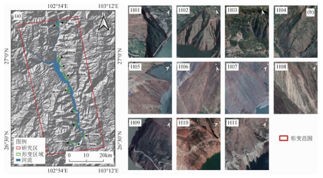
图4 InSAR识别形变区分布情况图(a)形变区域分布情况; (b)形变区的Google Earth影像图. Fig 4 InSAR recognition of deformation zone distribution (a) Distribution of deformation areas; (b) Google Earth image of the deformation zone. |
表2 InSAR形变区信息Table 2 InSAR deformation zone information |
| InSAR形变区类型 | 编号 | 最大形变速率/(mm·a-1) | SAR数据来源 | ||
|---|---|---|---|---|---|
| 蓄水前期 | 蓄水中期 | 蓄水后期 | |||
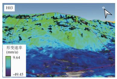
| 已知活动性滑坡 | H03 | 9.64 | 46.13 | 49.45 | Sentinel-1A升轨 |
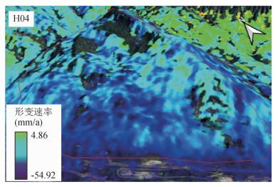
| H04 | 10.48 | 50.34 | 54.92 | Sentinel-1A升降轨 | |
| H06 | 24.56 | 62.65 | 95.45 | Sentinel-1A升降轨 | |
| H08 | 14.18 | 17.90 | 23.74 | Sentinel-1A升降轨 | |
| 潜在地质灾害隐患点 | H01 | 29.63 | 45.72 | 38.67 | Sentinel-1A升轨 |
| H02 | 5.72 | 31.98 | 25.58 | Sentinel-1A升轨 | |
| H05 | 11.84 | 6.61 | 19.97 | Sentinel-1A升降轨 | |
| H07 | 9.25 | 40.43 | 46.30 | Sentinel-1A升降轨 | |
| H09 | 13.54 | 43.08 | 39.11 | Sentinel-1A降轨 | |
| H10 | 4.08 | 17.20 | 8.82 | Sentinel-1A降轨 | |
| H11 | 4.53 | 28.69 | 15.47 | Sentinel-1A降轨 | |
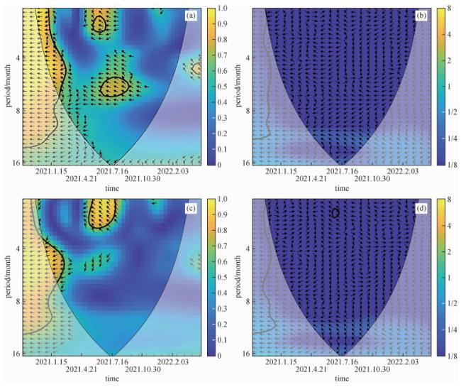
图9 典型滑坡时间序列形变和库区水位的小波分析图(a)跨山滑坡小波相干;(b)跨山滑坡交叉小波;(c)巧家县滑坡小波相干;(d)巧家县滑坡交叉小波. Fig 9 Wavelet analysis of typical landslide time series deformation and reservoir water level (a) Cross mountain landslide wavelet coherence; (b) Cross mountain landslide crossing wavelet; (c) Wavelet coherence of landslide in Qiaojia County; (d) The landslide crossing wavelet in Qiaojia County. |
感谢审稿专家提出的修改意见和编辑部的大力支持!
|
|
|
Benesty J, Chen J D, Huang Y T, et al. 2009. Pearson correlation coefficient. //Cohen I, Huang Y T, Chen J D, et al eds. Noise Reduction in Speech Processing. Berlin, Heidelberg: Springer, 1-4, doi: 10.1007/978-3-642-00296-0_5.
|
|
|
|
|
|
|
|
Ding Y Z. 2021. Study on stability of Qiaojia giant ancient landslide in Baihetan hydropower station the reservoir area[Master's thesis] (in Chinese). Qingdao: Shandong University of Science and Technology, doi: 10.27275/d.cnki.gsdku.2019.000549.
|
|
|
|
|
|
|
|
|
|
|
|
|
|
|
|
|
|
|
|
Meng R. 2020. Study on the deformation mechanism and evolution trend of Muyubao landslide in the Three Gorges Reservoir area[Master's thesis] (in Chinese). Chengdu: Chengdu University of Technology, doi: 10.26986/d.cnki.gcdlc.2020.001145.
|
|
|
|
|
|
|
|
|
|
|
|
|
|
|
|
|
|
Zhou Z K. 2022. Study of geo-hazards investigation for Baihetan reservoir bank by InSAR technology[Master's thesis] (in Chinese). Beijing: Chinese Academy of Geological Sciences, doi: 10.27744/d.cnki.gzgdk.2018.000006.
|
|
|
|
|
|
|
|
丁永政. 2021. 白鹤滩水电站库区巧家巨型古滑坡稳定性研究[硕士论文]. 青岛: 山东科技大学, doi: 10.27275/d.cnki.gsdku.2019.000549.
|
|
|
|
|
|
|
|
|
|
|
|
孟睿. 2020. 三峡库区木鱼包滑坡变形机理及演化趋势研究[硕士论文]. 成都: 成都理工大学, doi: 10.26986/d.cnki.gcdlc.2020.001145.
|
|
|
|
|
|
|
|
|
|
周振凯. 2022. 基于InSAR技术的白鹤滩水电站库区地质灾害调查研究[硕士论文]. 北京: 中国地质科学院, doi: 10.27744/d.cnki.gzgdk.2018.000006.
|
|
|
/
| 〈 |
|
〉 |