
Abbreviation (ISO4): Chin Agric Sci Bull
Editor in chief: Yulong YIN
Chinese Agricultural Science Bulletin >
Regionalization of the Climate Suitability on Pomegranate Planting in Xianyang Based on GIS
Received date: 2019-02-21
Request revised date: 2019-06-12
Online published: 2020-03-19
Supported by
(2017M-20)
Copyright
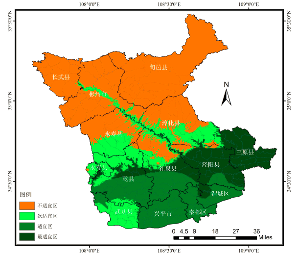
To study the climate suitability of pomegranate planting, make full use of climate resources, and find suitable areas for pomegranate cultivation in Xianyang, based on the latest meteorological observed data of 12 stations in Xianyang from 1988 to 2017, GIS technology was used to carry out climatic suitability regionalization of Xianyang pomegranate cultivation, aiming to provide a basis for pomegranate production and agricultural structure adjustment. There were 8 indices of climatic division for pomegranate, namely, ≥10℃ active accumulate temperature from bud emergence to fruit maturity, ≥10℃ active accumulate temperature during the annual growth period, sunshine hours of the year, sunshine hours on September, precipitation from July to September, the average temperature difference between day and night at 18-21℃, extreme minimum temperature of the year, extreme minimum temperature of ten days. The results showed that: the quality area of pomegranate cultivation accounted for 14.9%, mainly distributed in Sanyuan, most of Jingyang, northwest of Weicheng District, eastern Liquan, and northern Qianxian; the suitable area accounted for 21.3%, distributed in Xingping City, Qindu District, Weicheng District, the southern part of Liquan County, the southern part of Qianxian County and the Taiyuan District of Wugong north; the inferior area accounted for 16.6%, and the unsuitable area accounted for 47.2%. Except Wugong, the south of Xianyang dry belt is a suitable area for pomegranate planting, the light, heat and water climate resources in this area meet all the meteorological factors needed for high-quality production of pomegranate, and the cultivation of pomegranate can be developed in this region vigorously.
Key words: GIS; suitability; climate regionalization; pomegranate; Xianyang
Liu Yan , Liu Jin , Quan Wenting , Wang Jinting , Wang Zixuan , Liang Qichen . Regionalization of the Climate Suitability on Pomegranate Planting in Xianyang Based on GIS[J]. Chinese Agricultural Science Bulletin, 2020 , 36(10) : 109 -113 . DOI: 10.11924/j.issn.1000-6850.casb19020036
表1 咸阳市石榴种植气候区划指标 |
| 气候要素 | 最适宜条件 | 适宜条件 | 次适宜条件 | 不适宜条件 |
|---|---|---|---|---|
| K/℃·d | K≥3000 | 2000≤K<3000 | K<2000 | |
| Ka/℃·d | Ka≥4000 | 3000≤Ka<4000 | Ka<3000 | |
| TΔt/℃ | TΔt≥11 | 10.0≤TΔt<11.0 | TΔt<10.0 | |
| S/h | 2000≤S≤3500 | 1000≤S<2000 | S<1000或S>3500 | |
| S9/h | S9≥130 | 110≤S9<130 | S9<110 | |
| R7-9/mm | R7-9<280 | 280≤R7-9<300 | R7-9≥300 | |
| Tnmin/℃ | Tnmin≥-11.0 | -13.0≤Tn min<-11.0 | -15.0≤Tn min<-13.0 | Tnmin<-15.0 |
| Tx min/℃ | Tx min≥-5.0 | -5.0<Txmin≤-7.0 | -9.0≤Txmin<-7.0 | Txmin<-9.0 |
注:K代表从现蕾至果实成熟需≥10℃的有效积温,Ka代表年生长期内需≥10℃的有效积温,TΔt代表日平均气温18~21℃时的日较差,S代表年日照时数,S9代 |
表2 石榴种植区划因子空间分析模式 |
| 地理模式 | R | F |
|---|---|---|
| K=4671.949-1.786h | 0.987 | 389.003** |
| Ka=5270.915-1.702h | 0.984 | 299.010** |
| S=-11005.774+376.009φ | 0.751 | 12.920** |
| S9=-2684.687+25.832λ+0.030h | 0.802 | 8.117* |
| R7-9=239.373+0.059h | 0.840 | 23.945** |
| TΔt=-47.083+1.669φ | 0.728 | 11.276** |
| Tn=-6.374-0.010h | 0.904 | 44.914** |
| Tx=207.259-6.155φ | 0.934 | 67.982** |
注:λ、φ、h分别代表经度、纬度、高度。*代表P<0.05,**代表P<0.01。 |
The authors have declared that no competing interests exist.
作者已声明无竞争性利益关系。
感谢中国科学院计算机网络信息中心地理空间数据云(http://www.gscloud.cn)提供咸阳地区DEM(Digital Elevation Model,数字高程模型数据)。
| [1] |
陕西省统计局.2019年陕西省果业发展统计公报[R]. 2019.
|
| [2] |
咸阳市人民政府办公室关于印发咸阳市旱腰带地区石榴产业发展规划(2017—2025年)的通知[Z].
|
| [3] |
赵静,王昱,何倩茹.石榴生长主要物候期气象服务指标分析[J].资源与环境科学,2015(19):263-266.
|
| [4] |
陈家金,王加义,黄川容,等.台湾番石榴在福建引种的寒冻害风险分析与区划[J].生态学杂志,2015,34(4):967-973.
|
| [5] |
薜华柏,曹尚银,郭俊英,等.突尼斯软籽石榴气候区划北限及次适宜区的防寒栽培[J].中国果树,2010,3(2):63-64.
|
| [6] |
池再香,莫建国,康学良,等.基于GIS的贵州西部春薯种植气候适宜性精细化区划[J].中国农业气象,2012,33(1):93-97.
|
| [7] |
吉志红,陈敏,张心令.基于GIS的三门峡市苹果种植气候适宜性区划[J].气象与环境科学,2015,38(1):61-66.
|
| [8] |
魏钦平,张继祥,毛志泉,等.苹果优质生产的最适气象因子和气候区划[J].应用生态学报,2003,14(5):713-716.
|
| [9] |
张东方,张琴,郭杰,等.基于MaxEnt模型的当归全球生态适宜区和生态特征研究[J].生态学报,2017,37(15):5111-5120.
|
| [10] |
何燕,李政,廖雪萍.基于GIS的巴西陆稻IAPAR-9种植气候区划研究[J].应用气象学报,2007,18(2):219-224.
|
| [11] |
孙文堂,苗春生,沈建国,等.基于GIS的马铃薯种植气候区划及风险区划的研究[J].南京气象学院学报,2004,27(5):650-659.
|
| [12] |
|
| [13] |
魏丽,殷剑敏,王怀清.GIS支持下的江西省优质早稻种植气候区划[J].中国农业气象,2002,23(2):27-31.
|
| [14] |
尹东,尹红,张旭东.基于GIS的甘肃省纹党种植气候区划[J].中国农业气象,2011,32(2):246-249.
|
| [15] |
尹盟毅,刘新生,权文婷,等.基于GIS的咸阳富士苹果优质生产气候区划[J].陕西农业科学,2014,60(9):46-49.
|
| [16] |
梁轶,李星敏,周辉,等.陕西油菜生态气候适宜性分析与精细化区划[J].中国农业气象,2013,34(1):50-57.
|
| [17] |
张旭阳. 陕西省苹果气候适宜性专题区划研究[D].西安:陕西师范大学,2010.
|
| [18] |
郭兆夏,李星敏,朱琳,等.基于GIS技术的陕西白梨气候区划[J].果树学报,2010,27(5):698-702.
|
| [19] |
张艳. 陕西葡萄品种生态区划研究[D].杨凌:西北农林科技大学,2009.
|
| [20] |
郭兆夏,朱琳,李星敏,等.基于GIS技术的陕西砂梨气候区划[J].经济林果研究,2010,28(2):88-91.
|
| [21] |
郭兆夏,梁轶,王景红,等.GIS技术支持下的陕西核桃精细化气候适宜性区划[J].干旱地区农业研究,2015,33(1):194-198.
|
| [22] |
汤国安,杨昕.地理信息系统空间分析实验教程(第二版)[M].北京:科学出版社,2013:112-317.
|
| [23] |
李化龙,赵西社,朱海利,等.陕西黄土高原果业气候生态条件研究及应用[M].北京:气象出版社,2010:151-155.
|
| [24] |
冯玉增,胡静坡.石榴[M].北京:中国农业大学出版社,2005:45-52.
|
| [25] |
雷娟. 影响新余蜜橘品质的气象因子及其变化趋势[J].气象与减灾研究,2009,32(3):67-72.
|
| [26] |
张华. 石榴裂果的原因及预防措施[J].中国植保导刊,2009(3):26-27.
|
| [27] |
郭晓成. 陕西石榴产业现状、资源优势及发展建议[J].西北园艺,2005(12):46-49.
|
/
| 〈 |
|
〉 |